
Pond & Lake Sediment Studies
Planning a dredge project without knowing how much sediment is on the bottom leads to surprises in cost and permitting. Our team measures sediment depth, makeup, and volume with core samples and sonar, then delivers maps that take the guesswork out of the plan.
Branch Locations:
Raleigh-Durham, Charlotte, Winston-Salem / Greensboro, Wilmington, Myrtle Beach, Charleston, Greenville-Spartanburg, Atlanta, Savannah, Orlando, Tampa, Virginia Beach, Fairfax, Montgomery County, Lewes, Chicago, Houston, Dallas-Fort Worth, San Marcos Corridor, Nashville
Have a multi-site footprint? Learn how we can work with you
Service DescriptioN
About Our Pond & Lake Sediment Studies Service
A sediment study is a measurement of how much soft material has settled on the bottom of a pond or lake, what it is made of, and where it has collected.
Every waterbody fills in slowly. Soil, leaves, and organic material wash in, settle, and build a layer of muck over the original bottom. That layer takes up depth and storage, but because it builds a little at a time, it is hard to judge from the shore.
Dragonfly Pond Works measures sediment depth across the waterbody, takes samples where needed, and turns the results into maps and volume estimates anyone can read. The study works together with a bathymetric survey. The survey maps the depth and contours of the bottom, and the sediment study measures the sediment layer on top of it, so the two together give a clear removal volume. Owners, boards, and managers use those findings for dredge planning, budgeting, and permits, working from measured data instead of rough estimates.
The study supports the health, function, aesthetic appeal, and value of your waterbody by showing where attention will do the most good.

Key Benefits of Pond & Lake Sediment Studies
Know What You Are Working With
Measured sediment depth and volume replace guesses about how much material is on the bottom.
Accurate Dredge Planning
Contractors can scope and price removal based on measured volumes, which keeps bids comparable.
Support for Permits and Reporting
Sampling results show how the material can be handled, which agencies often ask for.
Better Use of Every Dollar
Knowing where sediment has collected lets you target the worst areas first.
A Record You Can Compare Over Time
A repeat sediment survey shows how fast the pond is filling in and whether upstream fixes are working.
Clear Reporting for Boards and Managers
Plain language findings make it easier for boards to explain the need to community members.
From The Field
Service Photos

How It Works
Planning the Survey
We review the size and shape of the waterbody and set a grid of measurement points that will give reliable results.
Measuring the Sediment
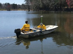
Our crews work across the water, recording sediment depth over the original bottom at each point on the grid.
Sampling
Where needed, we collect samples to show what the material is made of and how it should be handled.
Mapping and Volume
We turn the measurements into maps and an estimate of total accumulated volume.
Review and Recommendations
We walk through the findings with you, explain what they mean for the waterbody, and outline the options that follow.
Why Pond & Lake Sediment Studies is Important
Most ponds and lakes fill in slowly, so the change is easy to miss until boat access drops for residents and visitors, plants spread, or flooding shows up in the wrong place. By then, the work needed is larger than it had to be.
A sediment study gives you the information to act early and to spend on the right areas. We prioritize practical, well documented work, and we strive to leave every site better than we found it.
Pond & Lake Sediment Studies FAQs
Answers to our most common questions about this service. If you have a different question not answered here, get in touch.
It measures how thick the soft layer is across the bottom, estimates the total volume, and, with sampling, shows what the material contains.
It is strongly recommended. Dredge planning without measured volumes often leads to cost overruns or missed areas.
Many owners repeat the study every several years, or sooner after major storms or construction upstream. Comparing results shows how fast the waterbody is filling.
No. The work is done from a small boat and causes little disturbance to the water, wildlife, or people using the site.
You receive sediment maps, a volume estimate, sampling results where collected, and a written summary with recommended next steps.
Yes. We provide sediment studies for private homeowner ponds, HOAs, facility managers, municipalities, and community lakes.